RENO, Nev. — At 10:33 a.m., the Nevada Seismological Laboratory (NSL) recorded another large earthquake near Lahontan Reservoir, this time with a magnitude of 4.8. The quake was located about 13 miles southwest of Fallon, 20 miles north of Yerington at a depth of 4.6 miles. Hundreds of earthquakes have shaken communities in northwestern Nevada since April 13, when a magnitude 5.68 quake struck the same fault line near Lahontan Reservoir. Eighty-three of these have had magnitudes greater than 2.5.
“This earthquake sequence is on a fault we didn’t know about before it started, crossing the Dead Camel Mountains,” Christie Rowe, director of the NSL, said. “We’ve had reports of minor damage in Fallon and at Fort Churchill to some of the historic buildings.”
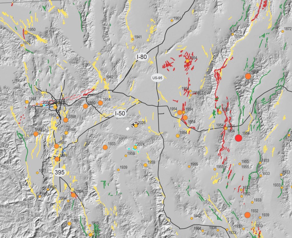
Nevada has thousands of faults across the state, but only the ones that have broken the surface in recent earthquakes are known to researchers.
“When a fault lies quiet for thousands of years, erosion can erase it from the landscape,” Rowe explained. “It lies hidden until the next earthquake.”
The NSL has recorded 371 earthquakes along the fault in the past 10 days and has deployed aftershock kits to more accurately measure seismic activity in the region, which were able to capture today’s quake with higher fidelity, providing more information to the seismologists. The lab will continue to closely monitor seismic activity in the region, and live earthquake monitoring is featured on the NSL website.
Rowe has been advocating for ShakeAlert, an earthquake early warning system, to be brought to Nevada. The system detects an earthquake using seismic stations and sends alerts to people who live within the likely shaking distance of the quake.
“Nevada is the third most seismically active state, but we don’t get alerts for earthquakes,” Rowe said.
The extra time an alert provides can allow someone to “Drop, Cover and Hold On” during an earthquake to protect themselves from potential damage during shaking. The federal budget for the 2026 Fiscal Year includes a directive for the U.S. Geological Survey to develop a plan for adding Nevada to the ShakeAlert program, thanks to strong support from Congressman Amodei and the rest of Nevada’s delegation.
“If we had ShakeAlert in Nevada, with an ideal installation, Reno would have had 10 to 15 seconds warning before feeling shaking from the 5.7 magnitude earthquake last week,” Rowe said. “When we get larger magnitude earthquakes, similar to the high 6 and 7 magnitudes of the early twentieth century, these warnings will save lives and property. ShakeAlert can also deliver warnings directly to emergency broadcast systems at remote facilities, beyond cell coverage.”
The series of earthquakes over the past week have served as a good reminder that Nevada is earthquake country and the importance of being prepared. The Great ShakeOut is an annual earthquake drill held in October to practice earthquake preparedness.
People who felt the earthquake can report their experience to the U.S. Geological Survey. This report provides important information to seismologists and can help fill in gaps between instruments.